How technology transforms fishing travel: better trips
TL;DR:
- Modern fishing technology enhances every stage of an angler’s trip, from pre-planning to on-water navigation and species identification. GPS and sonar systems provide precise underwater mapping, route safety, and hotspot revisits, while digital tools facilitate detailed trip research and gear selection. Combining technology with experience ensures safer, more productive fishing adventures while maintaining essential traditional skills.
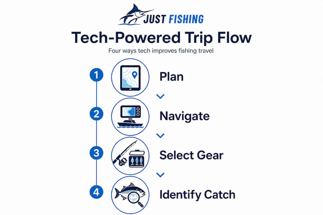
Most anglers assume technology means a better fish finder or a flashier lure. The truth goes much further. Today’s fishing tech reshapes every phase of your adventure, from choosing a destination and packing the right gear, to navigating open water in unfamiliar territory, to identifying that strange catch you’ve never seen before. GPS units, mobile apps, sonar systems, and digital gear tools now connect to form one powerful support system. This guide breaks down exactly how each piece works, where it fits into your trip, and how to use it without losing the instincts that make a great angler.
Table of Contents
- How navigation tools and fish finders reshape the journey
- Digital trip planning and remote research
- Tech-enabled gear selection: Choosing the right tools
- Digital identification and learning on the go
- Why treating technology as a toolkit, not a crutch, matters
- Gear up for your next high-tech fishing adventure
- Frequently asked questions
Key Takeaways
| Point | Details |
|---|---|
| GPS boosts safety | Using GPS waypoints helps anglers navigate new waters and find hotspots again safely. |
| Apps improve planning | Digital resources give you real-time data on weather, tides, and regulations before you leave home. |
| Smart gear selection | Online feedback and digital catalogs let you choose the best gear for your fishing location. |
| Tech is not flawless | Photo ID and sonar tools are powerful but must be used carefully and paired with angler skills. |
| Prepare and adapt | The best results come from combining technology with experience and a mindful, flexible approach. |
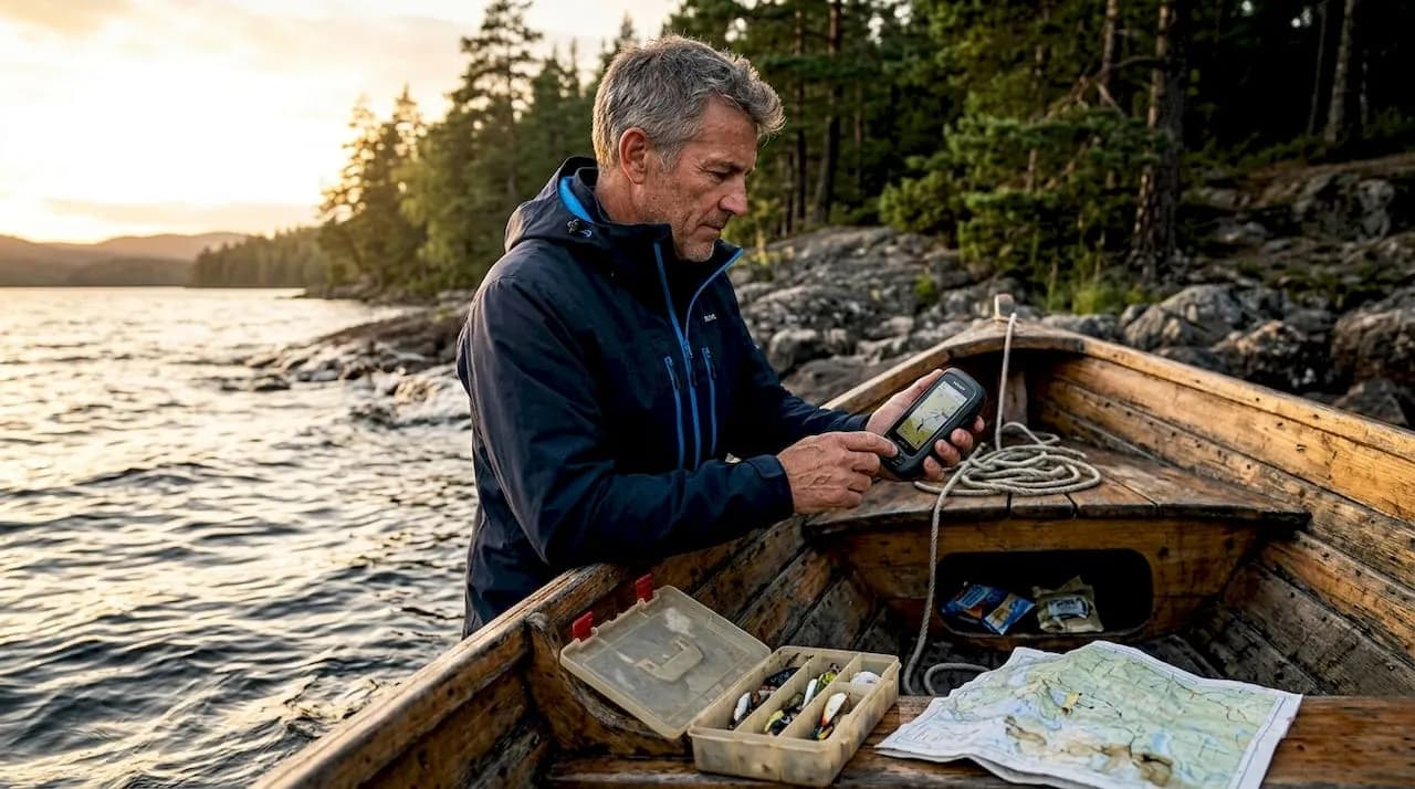
How navigation tools and fish finders reshape the journey
Once planning begins, the first major tech upgrade comes on the water. Modern GPS and sonar technology have moved far beyond simple “you are here” arrows on a screen. Today’s chartplotters combine satellite positioning with real-time sonar imaging to give you a clear picture of both your route and what lies beneath it.
GPS accuracy is typically about ±3 meters under open-sky conditions, which means your marked waypoints are reliable enough to revisit a productive reef or rock formation with precision. That level of accuracy changes how anglers approach unfamiliar water. Instead of relying on memory or rough compass bearings, you drop a waypoint at a productive spot and return to within a boat-length of it days or seasons later.
Sonar takes that a step further. When paired with GPS, it ties underwater images directly to geographic coordinates. You can see a bait school suspended at 40 feet over a ledge and mark it on your chart instantly. On your next trip, that mark tells you exactly what to expect before you even wet a line. This is how experienced boat anglers build a mental map over years, but technology now compresses that learning curve significantly.
Safety is another underappreciated benefit. When you’re running new water at dawn or in low visibility, a chartplotter loaded with current charts removes most of the guesswork. You know where the shoals are, where the channel runs, and how to get back if conditions change fast.
Key benefits of GPS and sonar for fishing travel:
- Mark productive hotspots and revisit them with meter-level precision
- Identify underwater structure, drop-offs, and bait schools in real time
- Store routes and return safely in poor visibility or unfamiliar areas
- Sync multiple devices so crew members share the same chart view
- Track your drift path to understand how current affects your presentations
| Feature | Basic GPS unit | GPS chartplotter with sonar |
|---|---|---|
| Position accuracy | ±3 to 5 meters | ±3 meters (open sky) |
| Underwater view | None | Real-time sonar imaging |
| Waypoint storage | Limited | Hundreds, tied to sonar marks |
| Chart integration | Basic | Full marine chart overlay |
| Safety features | Position only | Depth alarms, route alerts |
Pro Tip: Always pre-load your charts before leaving cell range. Offline chart data on a chartplotter means you’re never dependent on a signal to know where you are.
“The best fish finder in the world is only as good as the angler interpreting the data. Learn your unit’s settings before you leave the dock, not while you’re drifting over a reef.”
Improving your fishing trip experiences starts with getting the navigation right. When you know where you’re going and can document where you’ve been, every future trip builds on the last.
Digital trip planning and remote research
Accurate navigation on the water is only as good as the preparation that happens off the water. The planning phase used to mean calling charter operators, flipping through tide charts, and hoping the weather held. Now you can accomplish all of that and more from a laptop or phone before you book a single flight.
Modern fishing apps offer satellite imagery, tidal modeling, lunar phase data, and layered weather forecasts that go well beyond basic wind and rain predictions. You can check sea surface temperature maps to find temperature breaks where pelagic species congregate. Some apps show current predictions that reveal how water will move through your target area hour by hour. This level of detail was once reserved for commercial fishermen with expensive subscriptions.

GPS-enabled chartplotters now sync with these planning apps through Bluetooth or Wi-Fi connections, meaning the waypoints you plot at home transfer directly to your onboard unit. Your pre-trip research doesn’t get left behind on your phone screen. It becomes part of your on-water navigation system the moment you cast off.
A smart pre-trip digital planning process looks like this:
- Select your target species and destination using species range maps and seasonal fishing reports
- Cross-reference tidal windows with sunrise and sunset times for optimal feeding activity
- Check historical catch data and user reports for the specific area in the two to four weeks before your trip
- Review local regulations and size or bag limits using official government fisheries apps or websites
- Sync your planned waypoints and routes to your onboard GPS before departure
- Download offline weather and chart data in case connectivity drops on location
The Just Fishing guide covers destinations across multiple continents, each with distinct conditions and regulations. Using digital tools to research these locations ahead of time removes much of the anxiety that comes with fishing unfamiliar international waters. You arrive informed rather than guessing.
Pro Tip: Cross-check at least two weather sources when planning saltwater trips. Offshore conditions can shift quickly, and a single forecasting service won’t always capture local effects like afternoon thermal winds or sudden pressure drops.
Regulations are another major advantage of digital planning. Apps tied to government fisheries databases let you pull up current rules for any area, including protected species lists and seasonal closures. This saves you from an expensive fine and, more importantly, keeps fisheries healthy for future seasons.
Tech-enabled gear selection: Choosing the right tools
Once the trip plan is set, the next step is making informed gear choices. This is where technology plays a less obvious but equally powerful role. A generation ago, gear selection meant relying on a local tackle shop owner’s advice or trial and error over multiple seasons. Today, you can walk into any destination with a much more targeted setup.
Online communities, video platforms, and brand-specific mobile apps give you real-world performance data for specific species in specific conditions. You can watch footage of anglers fishing the same reef system you’re heading to and see exactly what lure style, retrieve speed, and rod weight produced results. That kind of specific, visual feedback is hard to overstate.
Virtual product comparison tools allow you to sort rods by action, length, and target species simultaneously. Reels can be filtered by gear ratio, drag rating, and line capacity before you’ve touched one in a store. Some brands offer augmented reality features that let you visualize gear at scale or even overlay rod action graphics so you understand how a blank flexes under load.
What technology-driven gear selection looks like in practice:
- Use species-specific forums to find which jig weights and profiles produce results in your target depth range
- Check digital catalog filters to shortlist rods rated for the exact line weight and lure range your technique demands
- Read review aggregates to identify consistent quality issues or standout features across multiple buyer experiences
- Watch rigging tutorials specific to your target species before arriving, so you rig correctly from the first cast
- Use tackle weight calculators to match sinker or jig weight to expected current speed at your target depth
For offshore bottom fishing or high-speed pelagic casting, the right jig profile matters enormously. Sonar interpretation depends on how your jig interacts with structure and local fish behavior, so gear and tech work together rather than independently. The Fish Art Torpedo Jig details are a good example of how purpose-built design translates into better results when you understand what the sonar is showing you.
Good gear selection also means adaptability. When conditions shift mid-trip, having researched multiple lure options in advance means you pivot faster than an angler who packed only one approach.
Digital identification and learning on the go
Once on the water, digital tools play a key role in live problem-solving and learning. Fishing new destinations almost always means encountering species you’ve never seen before. A decade ago, that meant a confusing conversation with the boat captain or a blank stare at a crumpled field guide.
Now, a clear photo taken on your phone can give you a working species identification in seconds. AI-powered identification apps analyze fin placement, body shape, color patterns, and scale structure to suggest the most likely match from a regional species database. Most apps also display size limits, bag limits, and whether a species is protected in your current location.
How to get the most from fish ID apps while on the water:
- Photograph the fish from the side with the dorsal fin fully erect for the clearest identification data
- Capture close-up images of distinguishing features like the lateral line, tail shape, and any distinctive markings
- Cross-reference the app suggestion with a second source before making release or retain decisions
- Log the catch with GPS coordinates so the data builds a personal library of where specific species appear
- Check local regulations in the same session, since many ID apps link directly to fisheries rules by region
Photo-based identification depends on image quality and can misclassify look-alikes. This matters most in regions with high species diversity like the Indo-Pacific or East African coast, where similar-looking species can have very different legal statuses. A blurry photo in low light is not reliable enough to make a final call on a protected fish.
Pro Tip: Take multiple photos from different angles before the fish revives and swims off. You can review the images carefully after you’ve made a good release, with no pressure to decide under time constraints.
Using smart lures designed for specific species groups becomes even more effective when you can identify exactly what’s in the water and adjust your presentation to match. Species ID and gear selection feed each other in a productive loop throughout the day.
The broader learning value is significant. Each unidentified fish becomes a data point when you log it digitally. Over a season or multiple trips, your app history gives you a personal species map that makes future planning sharper and more specific.
Why treating technology as a toolkit, not a crutch, matters
Here’s an uncomfortable truth that most tech-focused fishing content glosses over: the anglers who struggle most with electronics are often the ones who trust them unconditionally. The edge-case mindset for anglers means treating every consumer device as a fallible sensor. GPS accuracy can degrade with interference or heavy canopy cover. Sonar interpretation shifts depending on transducer mounting angle and local fish behavior. Photo-based identification can misclassify species with confidence that feels misleading.
We’ve seen anglers run confidently toward a chart mark only to find the depth sounder missed a shallow coral head that older local knowledge would have flagged immediately. Technology accelerates learning, but it doesn’t replace the judgment that comes from time on the water.
The real power comes from blending both worlds. Use your GPS to mark spots, then use tidal knowledge and wind reading to decide when to fish them. Run your sonar constantly, then interpret it against what you know about how your target species relates to structure in that specific environment. Let an ID app make an initial suggestion, then verify it against your own visual knowledge or a captain’s experience.
Battery life, device failures, and signal loss are not hypothetical. Packing a paper chart backup, carrying a hand compass, and knowing how to read the water without electronics are skills worth maintaining. They are not obstacles to high-tech fishing, but the safety net that makes high-tech fishing genuinely safe. Old-school local knowledge still finds fish that satellites and sonar miss entirely.
Gear up for your next high-tech fishing adventure
Putting all this technology to work is most rewarding when your gear and destination are matched precisely to your goals.
At JustFishing Group, we cover all your fishing needs from the latest lures and electronics to expert-curated destinations that reward a tech-prepared angler. Whether you’re targeting billfish in the Maldives or reef species off Socotra, our platform connects your research phase to your on-water reality. Book a trip through our destination pages to find detailed species information, seasonal windows, and gear recommendations tailored to each location. Explore our lineup from top fishing brands to find rods, reels, jigs, and accessories selected for the specific fisheries we operate in, so your tech-informed gear choices are backed by real destination experience.
Frequently asked questions
How accurate are fishing GPS devices for navigation?
Fishing GPS units are typically accurate within ±3 meters in open areas, but precision can drop with signal interference from heavy cloud cover, canopy, or nearby structures.
Can technology predict the best fishing spots in advance?
GPS-enabled chartplotters help you identify trends and repeat productive spots, but no device can guarantee fish will be present at a given location on any specific day.
Are mobile fish ID apps always correct?
Photo-based identification apps can misclassify look-alike species, particularly with poor image quality or in high-diversity regions where similar fish share overlapping ranges.
What are the most important tech upgrades for a fishing trip?
A reliable GPS with offline charts, a current-aware weather app, and a fish identification tool tied to local regulation databases are the three most impactful investments for most traveling anglers.
How does sonar help with fishing travel?
Pairing sonar with GPS gives you a real-time view of underwater structure, bait presence, and depth profiles that directly improves both spot selection and safe navigation in new water.